Friday, July 30, 2010

Western British Columbia


The air in Kamloops, BC Friday morning was thick with the haze of wildfires burning in parts of the province. We thought that we’d be following that haze all the way into Vancouver due to a fire in one of its suburbs, but were happy to see the air clear by mid day as we made our way south on route 99. The landscape around Kamloops is stark compared to what we had seen in the Rockies over the last few days, but returned to the dramatic snow-capped peaks as we neared Whistler and Squamish.

Route 99 is also known as the "Sea to Sky Highway" and is full of twists and turns and dramatic elevation changes (yes, that sign says "13%" grade!)
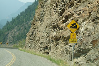
The section north of Whistler is in questionable shape in places, but the portion from Whistler on south to Vancouver was repaired and improved in preparation for the 2010 Winter Olympics.
Speaking of Whistler in the context of the Olympics, how could we stop there without a family picture in front of the 2010 Olympic rings?

The last surprise of the day as we neared Squamish was a breathtaking view of the Tantalus mountain range to the west of us – although only 2000 meters or less in height, the mountain tops are still covered with a thick mantle of snow (NOT a glacier).

More Canadian Rockies...and Beyond

Canada has its own, smaller “Glacier National Park” – but smaller only in acreage, not in beauty. We toured through there and Mt. Revelstoke National Park on Thursday, taking the auto road up Mt. Revelstoke and hiking around the top.


As to be expected, we’ve seen quite a number of foreign (non-U.S. or Canadian) tourists throughout the national parks. A general observation from past trips which seems to hold true this year: Asian tourists seem to prefer bus travel, while more often than not when we see a CruiseAmerica or CruiseCanada rental RV, it’s filled (often quite literally) with Europeans – this year, there seem to be many families from the Netherlands.


Thursday, July 29, 2010

Travelling with Gracie and Abby

We can’t be sure how Gracie and Abby feel about all this travel, but like to think they’re just content to be with us rather than left behind at a kennel or with a dog sitter. We know we’d miss having them with us and can’t count the number of people who have come up to us saying something like “may I pet your dogs? I had to leave mine at home”.

Still, travel with two large dogs has its challenges. Although we faithfully take them for extended walks every day, they are used to restraint-free romping in Vermont; being leashed every day when there are so many deer, bunnies, people, cats, and other dogs to play with or at least sniff apparently doesn’t seem fair to them. They manage to get their revenge, however: at best, their walker gets a vigorous upper body workout. At worst, they apply the “force = mass x acceleration” law of physics to their collective 150 lbs to drag their walker down hills and through flowerbeds, shrubbery and campsites, earning a helpless "NO!!!!" and disapproving looks from passersby.

Look at these faces - do they look innocent to you?

The Canadian Rockies


Northbound out of Waterton on Tuesday first brought us through rolling Alberta cattle and oil country. Alberta is the most oil-rich of the Canadian provinces, so gas prices are the lowest at approximately 90 cents per liter compare to up to $1.19 that we saw in parts of Ontario (a gallon is roughly 3.8 liters, so you do the math).
Turning west on Highway 541, however, we soon gained elevation as we entered the Canadian Rockies.


We stopped for the night in Canmore, and enjoyed the day Wednesday (a birthday Chris won't soon forget) touring Banff and Lake Louise.

The town of Banff is very commercial and touristy, although within the boundaries of Banff National Park -- the equivalent of placing Aspen or North Conway, with all of their privately owned condos and upscale homes in the middle of, say, Yosemite.


Looking back, I'm not sure that we took enough pictures of the scenery!

Wednesday, July 28, 2010

"Alberta, Alberta"

We will post more pictures of the Canadian Rockies in the next couple of days. We are in Canmore, just 15 miles from Banff and will spend today there.
We have been having bandwidth problems over the last few days, so our postings may be intermittent.

Tuesday, July 27, 2010

Waterton Lakes National Park


Glacier National Park is technically part of the Waterton-Glacier National Peace Park, Waterton being the Canadian National Park in Alberta that shares Glacier’s north border.
On Monday, we took one last tour within Glacier’s northeastern corner and headed directly into Waterton.
Our target destination that day was a campground in the town of Waterton Park, which, although being within the National Park itself, encompasses privately run shops, restaurants, and homes. While we were happy to get a campsite within the park, one thing we did not anticipate and have never experienced before was the proximity of the wildlife – specifically, deer walking freely on town streets and through the campsites.


The deer have apparently realized that the area is a good source of food and relatively safe from predators, and so are not at all afraid of the campers – in fact, the camp map we were given when entering warns that “some deer in town will attack without provocation” – especially pets. Needless to say, I was apprehensive about taking Gracie and Abby for their usual walk the next morning.
>
Leaving the killer deer behind for later, we took a drive up the park’s Akamina Parkway and took the dogs for a hike along the perimeter of Cameron Lake, the southern part of which touches the U.S. border (where we only had to worry about being in Grizzly bear country).
Waterton Park is also the location of the Prince of Wales Hotel, built in 1927-1928. One of the grand hotels in the tradition of others that were built to accommodate train travelers from the East in the late 19th and early 20th centuries, the Prince of Wales was also apparently built to lure wealthy Americans to Canada during the U.S. prohibition.


Killer deer or not, the view from our campsite at sunset was remarkable; this picture was taken just after 9 PM.

Sunday, July 25, 2010

Glacier National Park - Part 2


We returned to Glacier National Park from the eastern (St. Mary) end today, and hiked to Hidden Lake from the top of Logan Pass, encountering snow and some more bold mountain goats along the way....


We also hiked to St. Mary's falls.

Friday, July 23, 2010

Glacier National Park - Part 1

We arrived in the Glacier National Park area late Thursday; today, we took a van up the “Going-to-the-Sun” Road to Logan Pass (no RV’s allowed). After heavy rains last night, this morning dawned foggy so much of our trip up was shrouded in clouds.

When we got to Logan Pass, however, the weather cleared enough for some beautiful views.


Bonus – as we hiked along a path near the top, we came across a mother and baby mountain goat!


(More on Glacier in days to come)

Thursday, July 22, 2010

More Montana


According to the AAA Tour Book, the name Montana comes from the Spanish word for "mountainous" - a description that was obviously NOT bestowed by anyone coming into the state from the East. Today we reached the outskirts of Glacier National Park (pictures tomorrow), but most of the morning was characterized by dusty little plains towns, trains, and more wide open spaces.


The plains slowly turned into hills, and we came across yet another wind farm. No matter how many we've seen, they still fascinate us. The still camera can't capture their mvoement, but to me they've always looked like graceful and benign alien giants in a synchronized exercise class.

Wednesday, July 21, 2010

Montana


Planning to come back through North Dakota again on our way home in a few weeks, we bypassed Theodore Roosevelt National Park and the North Dakota Badlands for now, and opted instead to stay on U.S. 2 route through the northern North Dakota plains into Montana. Parts of route 2 loosely follow the Missouri River, so we thought it an appropriate time (and a way to break up the sameness of today’s scenery) to listen to “Undaunted Courage” on CD, tracing Lewis and Clark’s journey along the same river. Listening to the challenges they faced with disease, weather extremes, Indians, diminishing provisions, and difficult and uncertain terrain certainly put into perspective our complaints of having to walk the dogs in the rain, or of campgrounds lacking WiFi connectivity. Nevertheless, we find ourselves annoyed when campgrounds fall short of the descriptions we see in various camping guides (like the unmentioned proximity of tonight’s campground to the local railroad freight yards!).

On the bright side, we still prefer this mode of travel for a number of reasons – for one, being able to see how people live in the rest of the U.S., and also for the people we meet along the way: our neighbors in Williston, N.D. on Tuesday night included two men from California who are bicycling their way from Seattle to Bar Harbor, ME; tonight, we met a motorcyclist from Nova Scotia who was making his way to California and back in only four weeks!

Tuesday, July 20, 2010

North America Revolves Around Rugby


Rugby, North Dakota is the geographic center of North America.


West of Rugby, the northwestern part of North Dakota seems an endless stretch of canola (or maybe safflower?) fields, oil wells, and big sky.


Paul Bunyan


As we headed west Monday on U.S. Route 2, through miles of lakes and waterways, we drove through Grand Rapids, Minnesota, the birthplace and early home (now museum) of Judy Garland. Our lunch stop was in Bemidji, the “First City on the Mississippi”, located just a few miles from the river’s headwaters in Itasca State Park. Bemidji is a charming town on a lake of the same name, with a waterfront park that boasts an 18 foot statue of its “native son” Paul Bunyan, along with his blue ox “Babe”.

Perhaps it’s no coincidence that the state that lays claim to the giant lumberjack is also the state that elected Jessie Ventura as its leader. Take away Mr. Bunyan’s beard and dark head of hair and we think the resemblance to the former wrestling champ and governor speaks for itself!

"Highway 61 Revisited"


On Sunday, Route 61 took us along the western shore of Lake Superior from Thunder Bay to Duluth, Minnesota. Seeing a poster of Bob Dylan in Duluth, we had an ”aha!” moment as to the context of his 1965 “Highway 61…” album name. It also reminded us that Minnesota is indeed the state that produced Mr. Dylan (aka Robert Zimmerman), as well as the diverse likes of Garrison Keillor, Judy Garland, Walter Mondale, Hubert Humphrey, and Michele Bachmann.
Just south of the U.S.- Canada border, we visited Grand Portage National Monument (http://www.nps.gov/grpo/index.htm), the site of a footpath used by traders from Lake Superior to the Pigeon River back in the 17th-18th centuries. Faintly visible from the shore was Isle Royale National Park (http://www.nps.gov/isro/index.htm), a set of islands off the coast of Minnesota but belonging to Michigan.


To us, northern Minnesota has long been known for logging, but we didn’t realize that mining has played a large role in settling the area as well. The town of Twin Harbors, north of Duluth, is still a shipping port of iron ore from mines further north and west.
Duluth, with a population of 87,000, is less populous than Hartford, but is one of the worlds’ largest sea ports. What surprised us most about the city were its steep hills – for a state whose highest point is only 2300 feet, our climb from the ports and out of the city led us up some San Francisco- like streets to an elevation of 1400’ in a very short span.